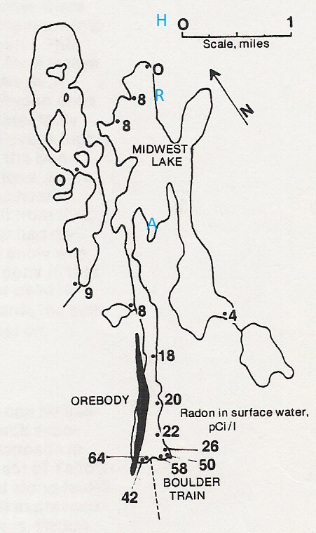
Midwest Lake
Radon in surface water
- I made this map around 1980 and added the locations in blue in December 2021. The Midwest Lake orebody is indicated in black as "OREBODY", the Midwest A deposit by the blue letter A, the Roughrider deposit including the J-zone deposit by the blue letter R, and the Huskie zone by the blue letter H.
- Note that the official name of this lake is South McMahon lake. Geologists call it Midwest Lake after the name of the diamond drilling company that did the intial drilling.
- Note the high radon values near the Midwest orebody and low values elsewhere.
- The radon anomaly was confirmed in 3 different summers by 3 different operators, all before the orebody was discovered by drilling.
- First (1969), Bondar-Clegg carried out a water survey at a spacing of one sample per square mile. This survey included only one sample near the orebody and it ran 19 pCi/L in radon, which they identified as "probably anomalous". This sample was not anomalous in uranium.
- Later (1972), in a more detailed survey, I collected water samples by canoe from shallow water around the edge and analysed them for radon in a tent. My results are shown in the figure.
- Several years later the orebody was discovered by the drill (shown in solid black on the figure)
- All the lakes in the region should be sampled like this, and in favourable areas bottom samples should be tested as well.
If the water in Midwest Lake had been a few feet higher,
the radioactive boulder train would have been submerged, but the orebody
could have been found with a radon survey.
We have similar results from Kiggavik.
We have similar results from Kiggavik.
